Authored by Mohan PM*,
Highlights
1. Existing studies suggested that there was some unexplained oceanographic process that happened in the nearshore regions.
2. Identification of some Submarine Ground Water Discharge (SGD) in and around study regions suggested that the above unexplained process may have a link with this process.
3. Suggested a combined oceanographic and hydrogeologic study essential to understand the nearshore marine environment process.
Highlights
The ground water moves into the seawater and mixes with the nearshore marine water due to its hydrological gradient is designated as a Submarine Ground Water Discharge (SGD). Reports from Hawaii west coast and Yucatan Peninsula suggested that all the freshwater entering into the sea as SGD. These flows (SGD) occur as spring and diffuse flow, through the continental shelf regions. The quantum of this mechanism was not understood properly. Similarly, the Andaman Islands also exhibit SGD since predominant volcanic out crop does not provide ample scope for the copious tropical torrential rainfall (3394mm/y) to perculate down and most of it divulges into the nearshore as SGD either through diffuse flow in many places or through springs in few places. The paucity of study from the area under the present investigation concerning SGD, leads to an attempt to understand the dynamics and impacts on the nearshore oceanographic process due to SGD. The existing literature also supports this factor. A submarine spring was also identified nearby island makes this concept more valid. However, an authenticated study, exclusively need for combination of groundwater and nearshore parameters may really reveal the factors, what’s is exactly happening in the nearshore environment, which may reverse the paradigm of nearshore eco-biological inferences.
Keywords: Submarine groundwater discharge; SGD; Islands; Andaman; India
Introduction
The ground water, due to its hydrological gradient moves into the seawater and mixing thereupon, designated as a Submarine Ground Water Discharge (SGD). Chruch [1] defined SGD as the direct outflow of groundwater through the ocean–land interface. This flow includes both groundwater and re-circulated portion of the salty groundwater. The SGD study has emerged as a hot research topic in the groundwater since last decade. This study may also cover the freshwater discharge through the ground, the recycled seawater and brackish water intrusion in the seawater. Church [1] and Moore [2] reported that the volume of SGD in the coastal oceans are almost comparable to river discharge, in their study locations. Kay et al., [3] and Hanshaw & Back [4], reported that, respectively, West coast of Hawaii and part of the Yucatan Peninsula exhibited almost all the freshwater enter into the ocean as SGD. Also, a volcanic island with a sandy coast discharge in the South Sea of Korea discharged freshwater at a rate of 50-300 m/y, which is higher than the continental coast region [5]. Since SGD occurs as spring and diffuse flow in continental shelf regions, the magnitude and mechanism are also poorly understood. The Andaman Islands with the poorly developed stream network system, unyielding acquifers and torrential rainfall (3394mm/y) may infiltrate through the fissures, cracks, and crevices of impervious subsurface volcanic rock. Since, the focus area is devoid of primary porosity to ground water and provide SGD as a spring in a few places and diffuse flow in majority of the areas of nearshore waters. The present study tries to evaluate whether any submarine ground water flow existed in this island environment through indirect shreds of evidences as well.
Materials and Methods
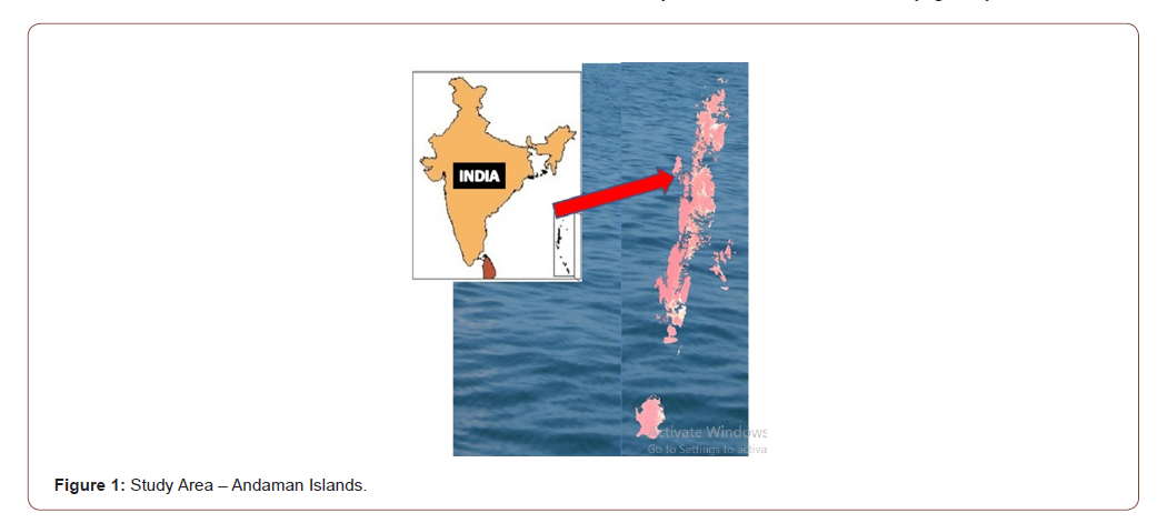
The present SGD evaluation was carried out through the different existing nearshore studies which was provided an unexplained variation of physical-chemical parameters and authors personal observations of freshwater inflow into the sea, in the study area of the Andaman Islands (Figure 1).
Results and Discussion
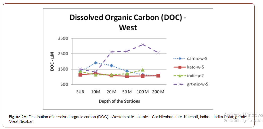
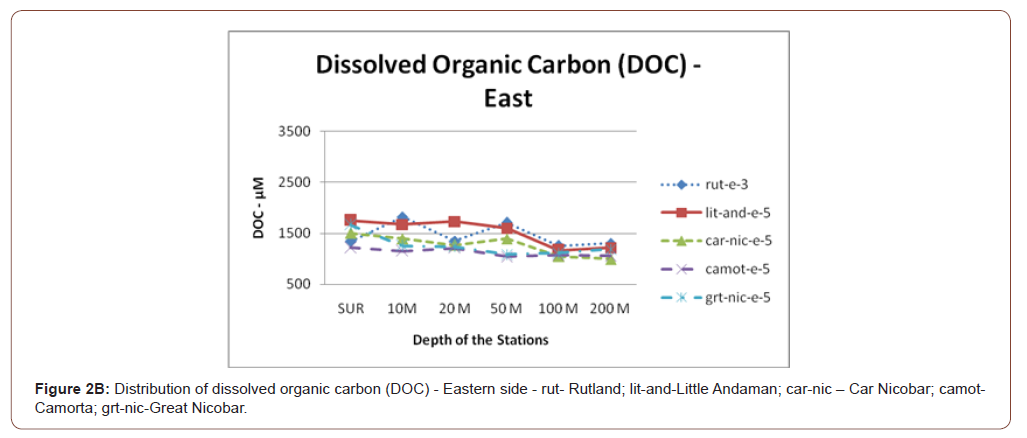
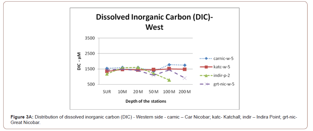
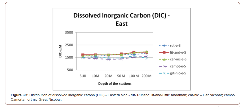
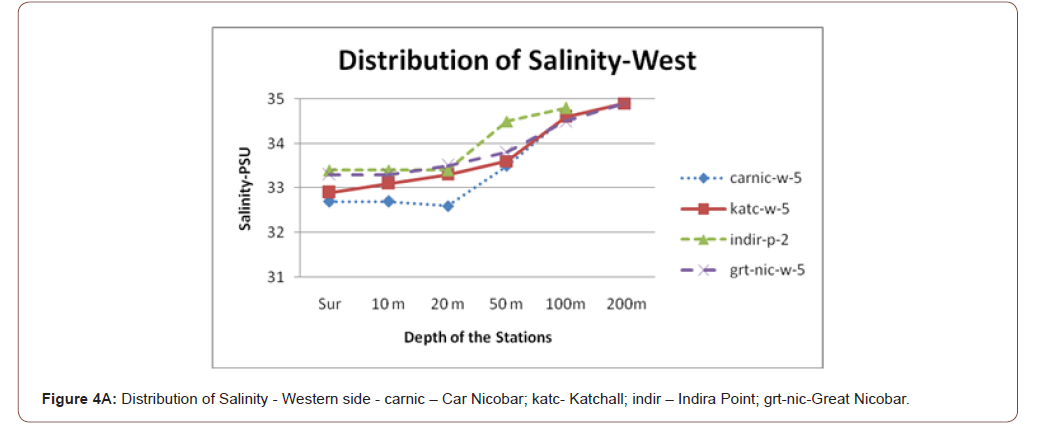
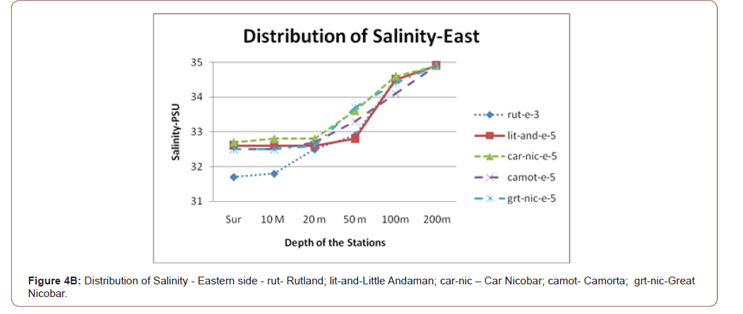
Case 1: The studies of Kumari et al., [6] suggested in the Nicobar Group of Islands showed a distinct increment or decrement of Dissolved Organic Carbon (DOC) and Dissolved Inorganic Carbon (DIC) with reference to depth i.e. surface to 50m (Figure 2A, 2B, 3A, 3B). Similarly, the salinity also exhibited a slight reduction in these depths (Figure 4A, 4B). These variations were not able to provide much explanation for the chemistry of the existing ocean waters. However, when incorporating the SGD concept, these variations may be inferred well than the existing explanations.
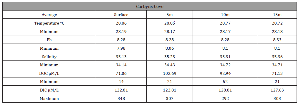
Case 2: Mohan et al., [7] studied the nearshore waters off Port Blair and found the significant variation of DOC and DIC concentration within the depth of surface to 15m water depth. Especially, when the analysis of DOC data revealed that between 5m and 10m depth, a sudden increase of DOC observed in all the three studied stations (Table 1A, 1B, 1C). The variation was around 20μM between the studied upper and bottom water column. Similarly, the DIC concentration also referred, it also showed a significant similar level of variation in these water columns. This sudden variation in the mid-depth was not able to explain the normal chemical processes which are known for the oceanographic process. Here, if one can assume that the SGD may have exercised its influence in these stations depth, this process was better explained.
Table 1:Distribution of Temperature, pH, Salinity, Dissolved Organic Carbon (DOC) and Dissolved Inorganic Carbon (DIC) - (8 nos) off Chatham Island.

Table 2:Distribution of Temperature, pH, Salinity, Dissolved Organic Carbon (DOC) and Dissolved Inorganic Carbon (DIC) - (8 nos) off North Bay Island.

Table 3:Distribution of Temperature, pH, Salinity, Dissolved Organic Carbon (DOC) and Dissolved Inorganic Carbon (DIC) - (8 nos) in off Carbyns Cove Island.
Case 3: Mohan et al., [8] conducted an experimental study in the laboratory conditions to mimic the similar kind of environment existed in the nearshore region articulated that the variation happened in the water column concerning DOC and DIC do not depict similar results to the naturally observed variations in the different water column. An insitu systematic reduction or increment took place in the existing water column. This study also supports that in the nearshore waters, other than the oceanographic process some other factor influenced this variation.
Case 4: Mohan & Kumari [9] studied four months of daily variation of temperature, salinity and pH in the nearshore waters of the Carbyns Cove beach (Table 2) suggested that there was an increment of salinity from 30.0 to 34.5, but the pH which was not showing any such an increment during this period (7.5 to 8.0). This variation was mainly observed during the period of non-rainy season, i.e. December to April. This was also suspected for SGD influences in this region, because the normal process of marine environment, freshwater input through rivers may provide an increment of elemental concentration and decrement of pH.
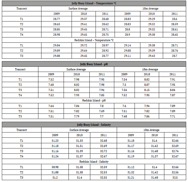
Case 5: Kumari & Mohan [10] studied in another two islands continuously three-year period for the temperature, salinity, and pH parameters of the waters (Table 3). This study showed very interesting fact that the water temperature comparatively higher in the bottom water (10m) temperature than the surface temperature, in certain periods. Further, it is also observed during non-rainy season period, the surface temperature value will be similar to next month bottom water temperature, i.e., the surface temperature in the month of April is 31.71⁰C, the May month bottom water (10m) depth temperature is 31.61⁰C in the same station. Further, during this studied period, the increment of salinity and pH also observed a significant increment, i.e., 1.32 to 1.51 and 0.41 units of pH. The interesting fact to be noticed in this study period is low rainfall and an increment of temperature was evidenced in the atmosphere. This increment of temperature at a depth of 10m, equivalent to surface water may be inferred with the influence of SGD impact.
Table 4:The Maxima and Minima Values of Temperature, Salinity and pH of Study Period.

Table 5:Average temperature, pH and salinity recorded in Joyy Buoy and Redskin Islands during the years 2009, 2010 and 2011.
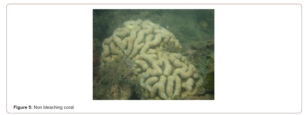
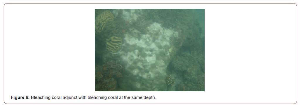
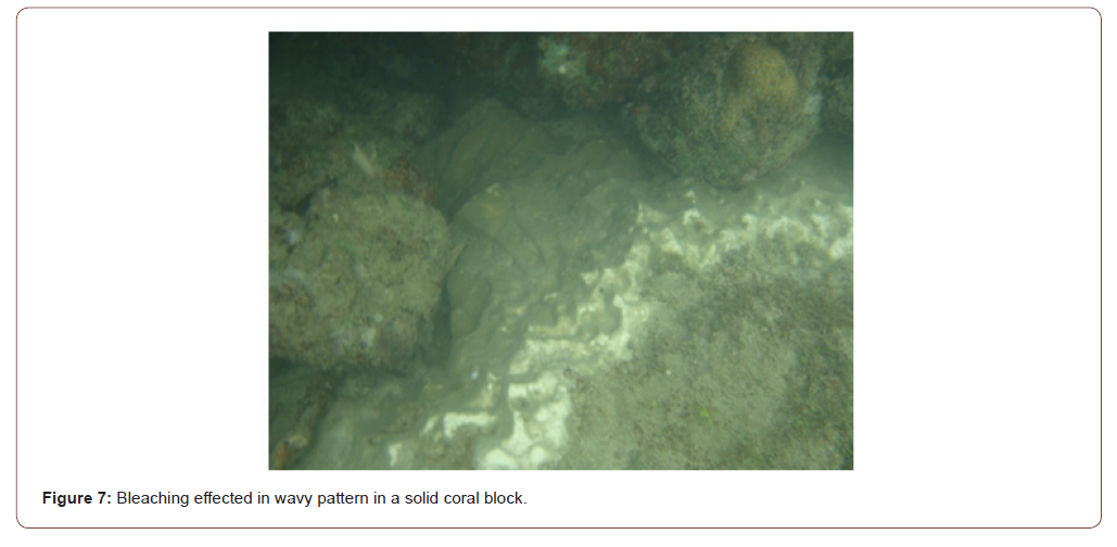
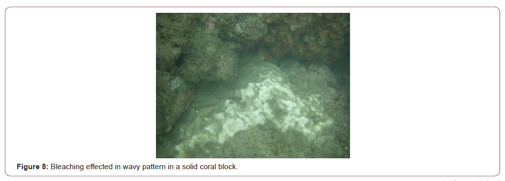
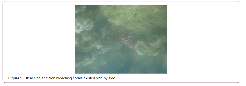
Case 6: Mohan et al., [11] reported that 2010 and 2015 coral reef bleaching was taken place in the Islands of Andaman suggested that in the year 2010, the bleaching was taken only LWM to 5m depth regions and in the year 2015, the bleaching was taken only by the wavy pattern and also less than 5m depth (Figures 5-9). The factor also suggested the increment in temperature of water column taken place only in the top 5m depth and corals were bleached. In the year 2015, a wavy selective bleaching observed in these locations also inferred better, if the influence of SGD may be considered, instead of the climatic variable influences for this process.
Case 7: Kumari [12] suggested that there is a clear cut reduction of salinity from the studied years 2014 to 2016, around a unit, invariably concerning an increment of temperature (Table 4), in the water column of 15m depth (Figures 10,11,14). This variance not only found it off the Port Blair coast. Almost 300 km distance, far away northern part of these islands also observed the same trend (Figures 12, 13). These findings were considered as a non-existing oceanographic process elsewhere discussed. However, considered it is the influence of SGD, then this finding will be clearly explained.
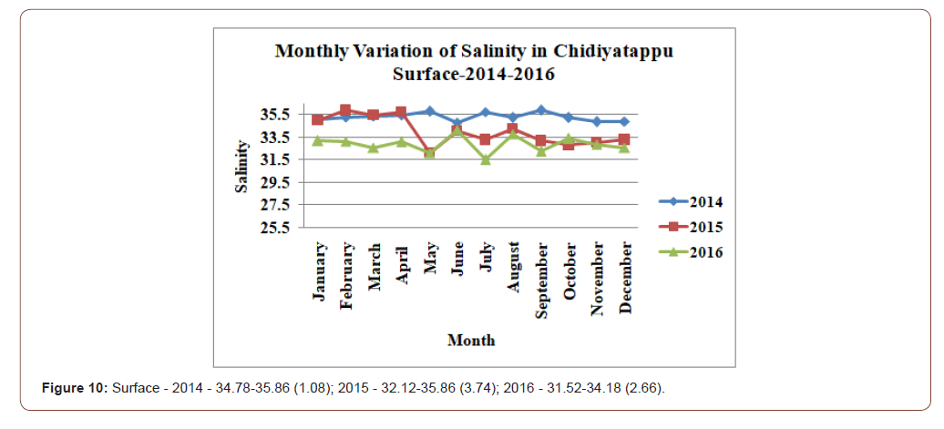
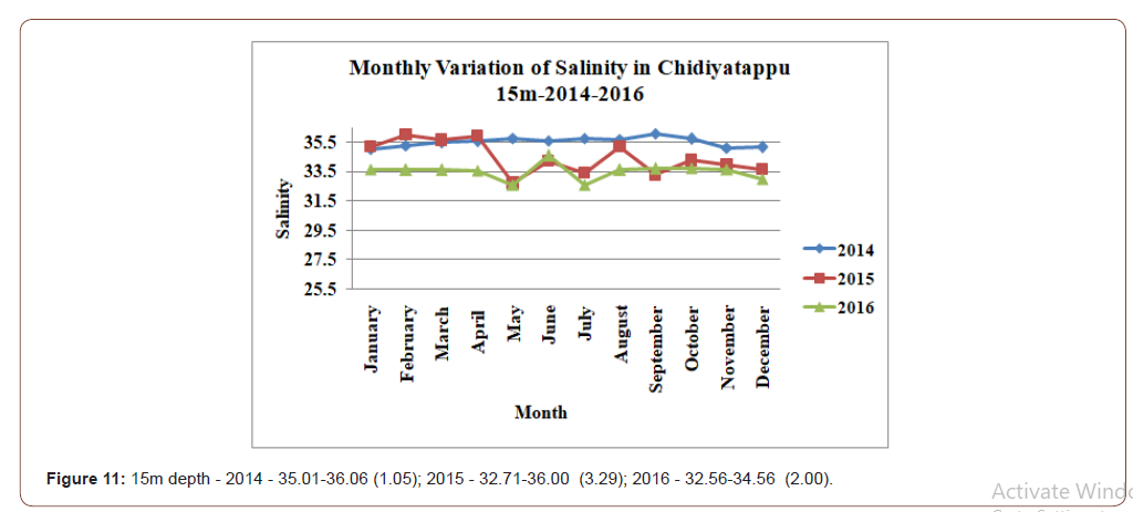
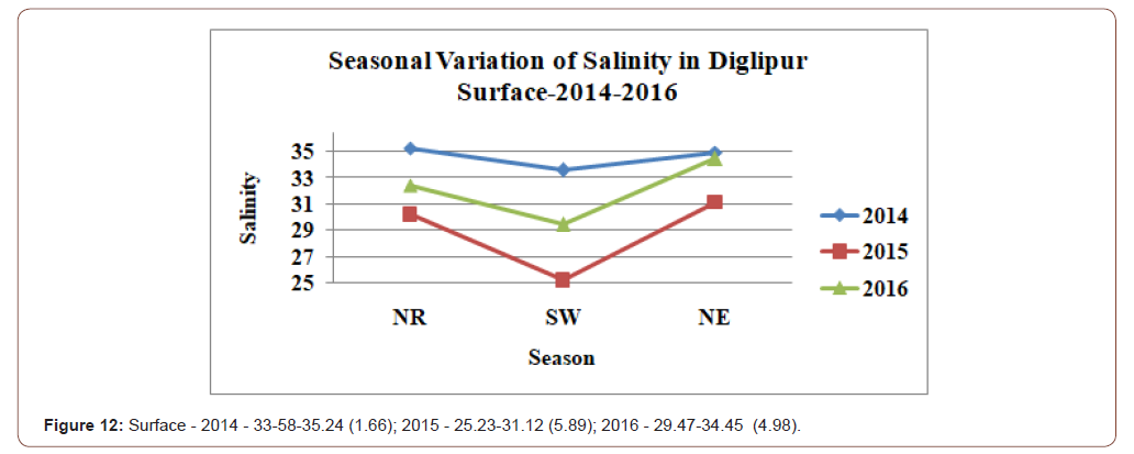
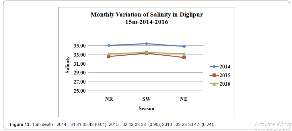
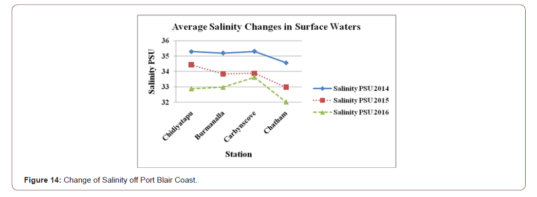
Table 4:The monthly rainfall data for the year 2013, 2014, 2015 and 2016 for Andaman Islands.

Existing Literatures
Johannes & Hearn [13], Lapointe & O’Connell [14], Slomp & Van Cappellen [15] and Luo et al. [16] reported that the nutrient rich, fresh water entered into the coastal ecosystem through SGD. Similarly, the reports of Burnett et al. [17], Moore [18] and Moosdorf et al. [19] suggested that the SGD is entering into the coastal waters universally. Taniguchi et al. [20] reported that almost 10% of the gross river runoff enters into the ocean as SGD. Dale & Miller [21], Waska & Kim [22], Encarnação et al. [23], Hata et al. [24], Amato et al. [25], Utsunomiya et al. [26], Lecher & Mackey [27], Piló et al. [28] and Foley [29] reported that the benthic community habitat modification may happen due to the influence of SGD which in turn increment of primary and secondary producer biomass. Lilkendey et al. [30] reported in the tide pool waters exhibited that the pure marine waters have a salinity of 35 PSU and fresh SGD influenced tide pool showed only 20 PSU during the four-month study.
SGD Study in the Present Studied Environment
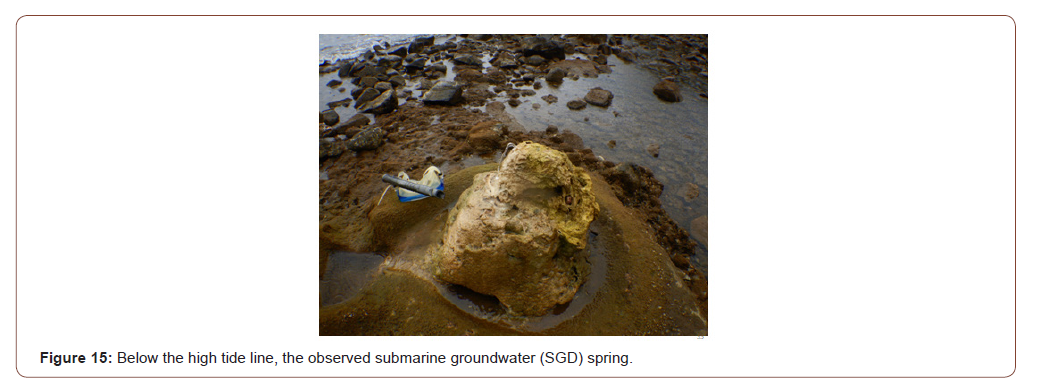
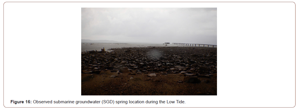
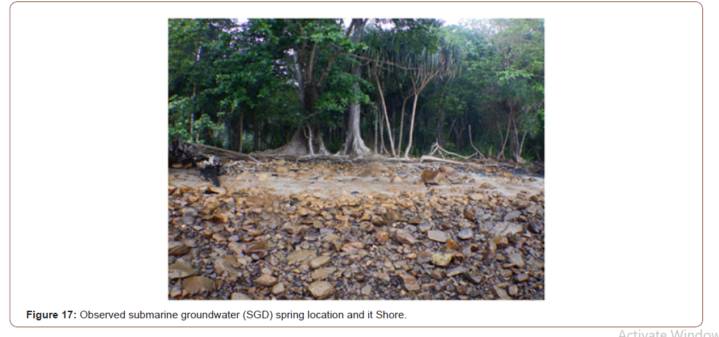
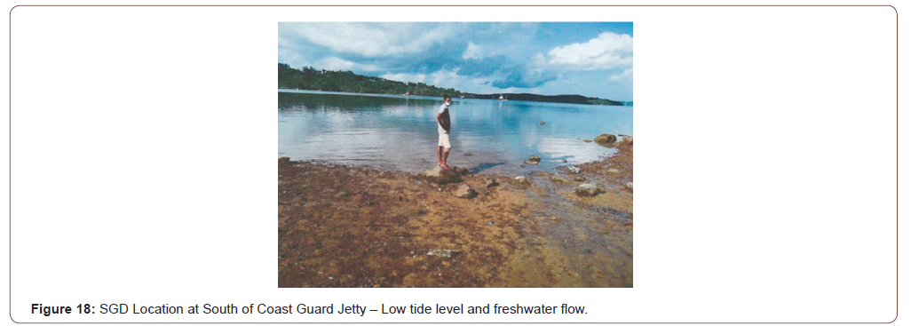
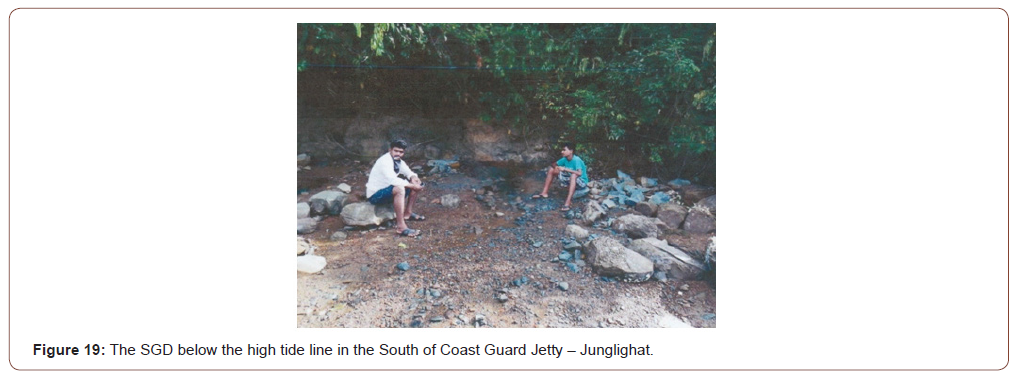
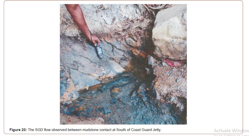
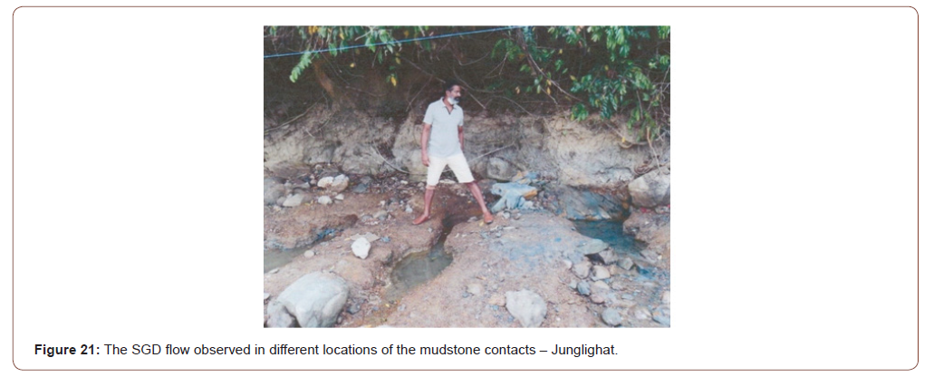
One of the Island near Port Blair called Rutland Island, opposite to Chidiyatappu, which has a location called Chain Nalah, where a submarine spring (Figures 15-17) was identified in the intertidal zone. This spring flow rate during Non-rainy season (April 2019) was 6.14ml/Sec. A day the water flow was identified 230.50 L/ day. So, the calculations showed that per year the flow was1.9 Lakh L/year. This water has a salinity of 0 PSU and pH is 11.094, i.e., highly alkaline nature. The studied period temperature is 24.5°C. Port Blair coast, near eastern side, close to the Coast Guard Jetty, the location (11°39’19.05N - 092°43’14.30E) is a steep clip of an alluvial soil, with a height of approximately 20m from the MSL (Figure 18). Entry into this part is restricted area due to the Coast Guard Jetty presence. During the low tide period, below the MSL, the flow of freshwater was observed through the mudstone and alluvial contact (Figure19). Three locations, within 50m distance (Figures 20-22). The water status is good with a flow rate of 5 ml/ sec. It has been estimated around 432 L/day and in the year it may around 1,55,520 L/year at a point. The length of the seepage may be around 4 m horizontal distance. The Salinity is 0.230 with a pH of 10.084 and the temperature is 22.5⁰C.
Conclusion
Overall understanding of the nearshore environment of this Island, based on the studied environmental parameters, suggested that over and above the natural oceanographic processes, the unidentified process also has an effect in this environment. The author’s perception is that it may be SGD, which has been evinced by identification two SGD sources along these coastlines, within short distance. So, a serious effort is essential to understand and revalidate the nearshore marine process by a joint venture of oceanographers and hydrologist, which provide a new vista for nearshore marine science environment concepts.
To read more about this article...Open access Journal of Oceanography & Marine Biology
Please follow the URL to access more information about this article
To know more about our Journals...Iris Publishers
To know about Open Access Publishers


No comments:
Post a Comment