Authored by Trahel Vardanyan*,
Abstract
This article discusses the impact of artificial lowering of lake water level on water ecosystems using the case study of Lake Sevan. Numerous rivers, lakes and, in general, water bodies have undergone considerable changes under the impact of the economic activity of man. As a result, hydrometrical, hydrological, biological, ecological conditions as well as the morphometrical elements of these bodies have been destroyed. Lake Sevan and its basin may serve as a classical example in this respect in the world limnology, there has been no other case when a lake level would be artificially lowered by 18 meters for 3-4 decades (1930-70 s), and by another 2 meters at the end of 20th century (1990-2000) and the volume of water in the lake decreased from 58 billion m3 to 32 billion m3. it must be noted that the drop of the lake level, and the economic development in the basin brought about the change in the hydrological regime of the lake. The latter caused the disruption of the hydro chemical and hydrobiological regimes of the lake. The quality of the water deteriorated; water turbidity increased. The inner circulation of the water substances, as well as the circulation of the biological substances altered as well.
Keywords:Lake ecosystems; Anthropogenic transformation; Hydrological regime; Hydro chemical regime; Hydrobiological regime; Eutrophication
Introduction
Numerous rivers, lakes and, in general, water bodies have undergone considerable changes under the impact of the economic activity of man. As a result, hydrometrical, hydrological, biological, ecological conditions as well as the morphometrical elements of these bodies have been destroyed. Lake Sevan and its basin may serve as a classical example in this respect (Figure 1).
In the world limnology, there has been no other case when a lake level would be artificially lowered by 18 meters for 3-4 decades (1930-70s), and by another 2 meters at the end of 20th century (1990-2000) and the volume of water in the lake decreased from 58 billion m3 to 32 billion m3.
The concept of using Lake Sevan water in a practical way appeared at the beginning of the 20th century. Because of Armenia’s dry subtropical climate, potential evaporation considerably exceeds the amount of precipitation. Water is a scarce resource for agriculture. In particular the Ararat valley, which is south of and 1000m lower than Lake Sevan, contains hundreds of thousands of hectares of arable land. But their annual precipitation is close to 300 mm, and potential evaporation above 1000 mm. Meanwhile millions of cubic meters of water were lost by evaporation from the lake.
The original proposal (Early 20th century) was to deepen the bed of the Hrazdan river and artificially increase the runoff. This would reduce the lake level by 55 m and increase the outflow of the Hrazdan river by 14-15 times, draining Big Sevan but using the water to irrigate 120 thousand ha immediately downstream and in the Ararat valley. It would also allow construction of a cascade of hydropower stations on the Hrazdan river. However, the First World War intervened [1].
Not until Soviet times was the project reconsidered. In 1931, after partial changes, the project was approved by the government and construction started. After building Kanaker and Yerevan hydropower stations, the construction of Sevan-Hrazdan hydropower cascade was interrupted by the Second World War. Work re-started in the early 1960s, and further power stations were built. The implementation of this project fostered the development of agriculture, energy, industry, and socio-economic activities. However, it gave rise to a number of ecological issues, caused primarily by the decrease of the level of the lake.
The anthropogenic changes in the level of Lake Sevan took place during the last eighty years after the decision to deepen the riverbed of the Hrazdan river (Figure 1) the only river flowing out of the lake, with the aim of using the lake water for irrigation and energy generation.
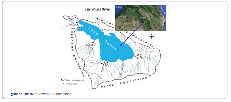
The aim of the research is to show, on the case study of Lake Sevan and its basin, what influence the dynamics of the artificial lowering of the lake water level has had on the lake, modern problems of their management and reviews the current attempts to make the lake sustainable after many years of lowered levels.
Research Area, Material and Methods
Research area
The area of research belongs to one of the most important areas of hydro ecology-the transformation of lake ecosystems, a striking example of which can be Lake Sevan Sevan is one of the high-mountainous freshwater lakes in the world and is the largest lake in Caucasus. Sevan is regarded to be a large reservoir of fresh water not only for Armenia, but also for the countries of the region (Figure 1).
Lake Sevan is perceived as a miracle of nature, an ecologically and economically significant water body, and a national treasure for Armenia. At 1900 m above sea level, it is one of the highest lakes in the world. But it is especially unusual because it is a freshwater lake located in the dry subtropical climate belt. Other lakes in the same belt, such as Van and Urmia (in the Armenian Highland), the Dead Sea, Tuz (Middle East), Lobnor (Central Asia), Issik-Kul (Central Asia), are all salty and their water is not fit for irrigation and drinking [2]. The salinity of Lake Sevan water is only 600-700 mg/l. Thus, it is a major source of water for Armenia, and potentially for other countries in the region. The lake is surrounded by mountain ranges exceeding 3000 m in altitude which are the sources for the water for the numerous streams flowing into the lake. The Areguni, Sevan and East Sevan are folded block mountains stretching along the main axis of the lake towards the north-east, while the south-west is encircled by the Geghama and Vardenis volcanic mountains (Figure 1). The Hrazdan River currently provides the natural outflow, with the river waters being used downstream for hydropower generation and for irrigation.
The concept of using Lake Sevan water in a practical way appeared at the beginning of the 20th century. Because of Armenia’s dry subtropical climate, potential evaporation considerably exceeds the amount of precipitation. Water is a scarce resource for agriculture. In particular the Ararat valley, which is south of and 1000m lower than Lake Sevan, contains hundreds of thousands of hectares of arable land. But their annual precipitation is close to 300 mm, and potential evaporation above 1000 mm. Meanwhile millions of cubic meters of water were lost by evaporation from the lake.
The Lake Sevan basin is characterized by a continental mountain-steppe climate. The coastal zone of the Lake Sevan is characterized by a temperate climate with warm long summers and relatively cold winters. In higher parts, the climate changes somewhat, summers become cooler, winters – colder. The high location of the basin, as well as the relative dryness of the air, determine the long duration of sunshine, which exceeds 2500 hours per year (in Martuni, about 2800 hours). The warmest month is August, when the average monthly temperature ranges from 8.8°С (Yeratumber) to 17.6°С (Shorzha), and the coldest month is January with an average monthly temperature of -4.6°С (Shorzha) to -12.3°С (Yeratumber). The average annual temperature ranges from -2.3°С (Yeratumber) to 6.4°С (Shorzha). In winter, a stable snow cover is formed. The precipitation in the basin ranges from 386 (Tsovak) to 857 (Yeratumber) mm. During the year, the maximum amount of precipitation is observed in spring, mainly in May, and the minimum - in winter [3].
Lake Sevan has been known throughout history, with information found in the works of ancient Greek chroniclers and geographers. According to the French traveler, Saint-Martain, Lake Lychnites on the map drawn by Ptolemy is Lake Sevan. There are several theories regarding the origin of the lake, the most plausible one being the tectonic-retaining theory [4]. According to this theory, the lake was formed in a tectonic depression as a result of dams created by lava flows from the Geghama mountains. Lake Sevan is divided by the Noratus and Artanish promontories into two major basins, Big and Small Sevan. In the upper Pleistocene, about 150- 200 thousand years ago, volcanic outflows finally blocked the valley the Hrazdan River [5].
The scientific study of Lake Sevan started at the end of the 19th century. The first relatively comprehensive survey was undertaken by Markov (1911). In 1928 Davidov VK [6] established the Hydro- Meteorological Bureau of Sevan, installed hydrological and meteorological stations, and commenced routine observations. Eventually the lake’s water balance Davidov VK [6], and salinity balance Lyatti S Ya [7], were estimated. Since then, human actions, superimposed on natural events, have led to many changes in these balances, most readily reflected in lake-level changes.
Material and methods
For the implementation of the article were used the meteorological and hydrological data taken from Arm state hydromet official observations [3], Hydrometeorology and Monitoring Center state non-commercial organization, from different departments (Institute of Hydro ecology and Fisheries; Yerevan State University; et al.), existing scientific sources, as well as climatic and hydrological atlases [8].
According to the Hydrometeorology and Monitoring Center*, in July 2019, water sampling was carried out at 14 observation points to study the water quality of Lake Sevan.
The water samples were taken from the coastal zone to the center of the lake. In the coastal zone the water samples were taken from the surface (up to 0.5 m depth) and from ground layers. In the central zone of the lake the water samples were taken from the surface, middle and ground layers. In total, 40 water samples were taken from the Big and Small Sevan.
The following physicochemical indicators were studied to assess the water quality of the lake.
a. Indices of saline conditions (total dissolved salts, major cations ions);
b. Living conditions indicators (nitrate + nitrite, ammonium, total nitrogen, total phosphorus, phosphate ion, total organic carbon);
c. Transparency (Secchi disk, color, and suspensions);
d. Oxygen conditions (dissolved oxygen, oxygen saturation, 5-day biochemical oxygen demand, chemical oxygen demand, total organic carbon);
e. Acid status indicators (pH, hydro carbonate, and carbonate ions);
To process the initial data, the basic principles, and methods of spatial-temporal analysis (general geographic, physical-geographic, hydrometeorological, socio-economic, hydro ecological) and the synthesis of relevant data and generalizations were used [9-12].
In the study of hydrometeorological and hydro chemical information, we used empirical-statistical and genetic theoretical models, methods of mathematical statistical analysis, field expeditionary observations, processing techniques of specialized databases, geographic information systems, and other methods and techniques used in practice were used [10,13-16].
Results and Discussion
The transformation of hydrometric and hydrological regime and existing problems
As already noted, the level of Lake Sevan was artificially lowered by 18 meters for 3-4 decades (1930- 1970) and by another 2 meters at the end of the 20th century (1990-2000) (Figure 2& 3).
The decline in the level of Lake Sevan during the 20th century has had major consequences for the physical, chemical, and biological character of the lake and its surrounding region. The early decreases were the result of human actions taken for practical purposes, and without concern for the consequences to the lake. More recently, as the deterioration of the lake environment became more apparent and better understood, restoration and increased lake levels became a consideration in any project involving the lake.
The 1960’s, concern for the preservation and restoration of Lake Sevan and its ecosystem began to emerge. To achieve restoration, water had to be provided to the lake from neighboring river basins. In 1961 it was proposed to construct the Arpa-Sevan water-carrying tunnel. The planned tunnel was 48 km long, passed under the Vardenis mountain range (Figure 1) and was supposed to carry 250 million m3 of water annually from the Arpa river.
After the construction of Arpa-Sevan tunnel in 1982-90, a positive water balance was established in the lake and the level started to rise gradually (Figure 2). As a result, biological and chemical changes and associated physical processes encouraged biological productivity and the lake rehabilitation was becoming sustainable.
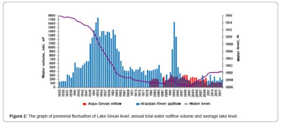

However, the sustainability was interrupted by the economic crisis in Armenia, and from 1992 on, large water releases from the Lake restarted. Thus, a secondary destabilizing of the lake stated, giving a further decrease in level, which caused the accumulation of organic substances in the lake, a trend towards eutrophication, and the redevelopment of the major problems.
Originally, before 1930, the surface of Lake Sevan was on the height of 1916 m above sea level. The surface of the drainage area of the lake before its artificial drop (1930s) was 3475 km2, that is larger than the surface of the lake by 2.5 times (1416 km2), and the volume of lake water was 58 billion m3 (Table 1).
Table 1: Some hydrometric indices of Lake Sevan.

this respect, Sevan is the only lake, which is considered to be a large natural laboratory, where one can observe all those processes, connected with the decrease of erosion basis of flowing into the lake rivers, and which cannot be studied under laboratory conditions. Among these processes, the hydrological, thermal, hydro-chemical, carbon regime of the lake, as well as biological conditions, which have served as a rich material for scientific research, are rather important.
The decrease of erosion basis caused the activation of channel processes of flowing into the lake rivers. It brought about the violation of the balanced profiles of river valleys, formed within thousands of years. The active down-cutting erosion destroyed the foundations of bridges and caused their collapse.
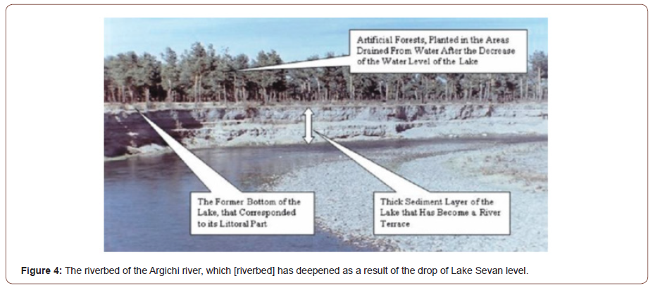
Down-cutting erosion is characteristic of all the rivers which flow into Lake Sevan. However, the erosion is rather vividly expressed in the river-mouth of the largest inflowing river, the Argiji, where the river has deepened its riverbed by 10-15m (Figure 4).
Lake Sevan is fed by water from inflowing rivers, precipitation falling on the surface and by groundwater inflow. Water is removed from the lake by evaporation, infiltration, and flow out through the Hrazdan river.
Rivers are the main water source (Figure 2). There are 28 rivers and streams of 10 km and longer (Table 2). The river network is rather dense in the south and south-western parts of the basin, which has the largest rivers, the Argiji, Gavaraget, Masrik, and Vardenis.
All the rivers of the basin together provide a mean annual water volume of 720-777 million m3. The other stream of inflowing water, the Arpa-Sevan tunnel, provides 219-236 million m3 of water (Table 3).
Table 2: Some hydrometric and hydrological characteristics of relatively large rivers of the basin of Lake Sevan.

Table 3: Some hydrometric indices of Lake Sevan.
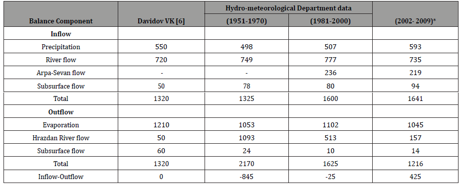
Water balance Lake Sevan before the descent of its level was first composed by Davidov in 1938 (Davidov 1938). Various water balance components, and their changes over time, are summarized in Table 3.
Precipitation and the river flow, as the main components of the inflow, remained almost unchanged, on the other hand, the groundwater flow increased almost twice. The Arpa-Sevan tunnel has been added as an input component since 1981, which annually transports 220-240 million m3 water from the Arpa River basin water to Lake Sevan.
One of the three components of outflow - evaporation, has always been, and still remains, the major component. Davidov VK [6], estimate was for 1210 mm per year, while the 2002-2009 average estimated was 1045 mm. This suggests rather small variations in evaporation. In contrast water outflow via the Hrazdan river is subject to great variations, since it is totally regulated by man. In natural condition it was 50 million m3, in 1960 it reached 1.7 billion m3, while in 1981-2000, it was 513 million m3, and now, according to the government’s decision, it reaches up to 120-140 million m3 per year.
Various authors have estimated the loss through subsurface flow in natural conditions as between 60 and 80 million m3. After the drop of the level the flow considerably decreased because many of the springs that came out on the valley of the Hrazdan river have dried out. During the past decade average infiltration constituted 10-15 million m3 annually.
Davidov VK [6], working with the natural conditions, indicated that the inflow and outflow were approximately equal. However, after the artificial reduction of the lake level, the annual difference between the inflow and outflow has almost always given a negative balance (Table 3). In 1951-1970 the balance was highly negative (-845 million m3), but this was reduced in 1981-2000 (-25 million m3) (Table 3). In the recent years, the outflow component has been considerably reduced, while steps are being taken to increase the inflow and create a positive balance (+425 million m3) and a rise in levels.
The studies of separate components of Lake Sevan balance show that under conditions of the global climate warming, evaporation from the lake’s surface may reach up to 145 × 106 m3/ annum. Averaging of the consequences of possible climate change on river runoff points at the possible decrease of water resources of the lake’s basin by−2.51% by the end of the first half of the twentyfirst century [2].
If Lake Sevan is to be reestablished as a viable fresh-water lake, there is need for an increase in lake levels above the current value. During the past 20-30 years, the status of and processes within Lake Sevan has been investigated by a number of scientificresearch institutes, scientific expedition groups, and scientists from Armenia, the former USSR, and foreign countries. They agree that a rise in lake level is needed in order to slow down or stop the eutrophication processes in the lake and reverse the deterioration of the lake environment. Most suggest that the lake level must be increased by at least 6 meters.
If the level rises more than that, the coastal recent constructions (roads, railway, resort houses and others) as well as tree-shrub vegetation (they were artificially planted and grown after the drop of water level) will go under water. However, the latter one is reality today (Figure 5). In the recent 10 years the water level of the lake has increased by more than two meters, which is the effect of the growth surface flow and decrease of outflow from the lake.
Table 4: The Mineralization of Lake Sevan water and its ionic composition in different years (mg/l).

Table 1: Study Areas in Anambra and Imo States.

As a result, a new issue emerged, namely, the coastal green zone is under water (considerable water lever increase took place so fast and unexpectedly, that there was no time to clear the coastal line from its green cover), thus, endangering the lake with eutrophication anew Thus, the river-mouths of rivers, which flow into the lake, have shifted (now, in the reverse direction, i.e., up the stream). And the former riverbeds formed at the bottom of the lake get filled with young loose river-drift sediment.
It is hard to predict the future developments of these processes. However, the issue of Lake Sevan is not entirely settled, the ecosystem of the lake is damaged, undergoing the process of eutrophication. The flora and fauna of the water and coast underwent serious and irreversible changes.
The transformation of hydro chemical regime and existing problems
Lake Sevan is one of the world’s fresh-water lakes. Studies of the chemical composition of the water of lake were launched at the end of the 19th century. Numerous studies have been conducted on the mineralization of Lake Sevan [17-24], and the first salt balance was determined in the 1930s [7].
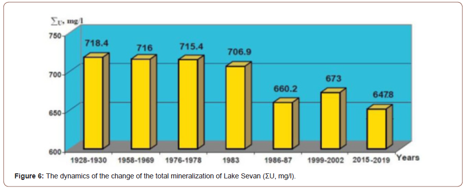
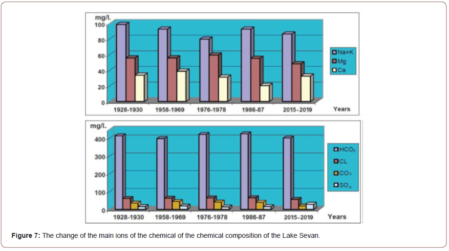
Let’s observe the total mineralization (Figure 6) and chemical composition (Table 4 & Figure 7) of Lake Sevan water in natural state, i.e., before its artificial lowering (1930), and the changes that have taken place since then.
In 1893, well before the artificial change in level of lake, the total mineralization was 714 mg/l (Stakhovsky 1895). It was 718.4 mg/l in 1928-30 [7]. Even during the rapid changes of 1958-1968 it changed little, being 717 mg/l in 1969 [17]. After 1980 the mineralization sharply decreased, becoming 706.9 mg/l in 1983 Parparova RM [20], as low as 660.2 mg/l in 1986-87 Vardanian TG [23], 673 mg/l in 1999-2002* and 647.8 mg/l at present*.
The decrease of the total mineralization of the water is strongly related to the massive outflow of salty water, removing the salts which had been accumulating in the lake for ages. For comparison, the total mean mineralization of the river waters flowing into the lake is 160-180 mg/l Vardanian T [24].
The declined dynamic of the total mineralization of the lake is because of the fact that about 45% of the total volume of salty water accumulated in the lake has flown out of the Hrazdan River for more than 70 years. However, the freshwater inflow, through the rivers and precipitation, have remained almost the same, also the water transported by Arpa-Sevan has increased since 1981 (Table 3 & Figure 2).
Almost all the ion concentrations have changed by about 5-68% as a result of the drop of the lake level. Most of them have decreased: The carbonate ion (CO3) concentration has changed most. If before the drop in the lake level was 36.0 mg/l, now it is 11.6 mg/l (-68%).
At the same time, the hydrogen indicator, pH, now 8.7, has undergone little change. This phenomenon has not yet been closely studied, but some opinions link the lack of calcium in Sevan water to the intensification of plankton photosynthesis. Studies have shown Riba I, et al. [25], revealed that acidity increased the concentration of several metal ions (Cr, Ni, Cu, Zn, Cd and Pb) but reduced its availability to the organisms, probably related to the reactivity of the ions with most non-metals or to the competition among metals and other waterborne constituents.
Form the studied ionic composition, only sulfate ion (SO4) increased about 1.8 times (Table 4), which affected the taste of water and may promote the growth of bacteria.
In the ionic composition of Lake Sevan, bicarbonate-ion (HCO3) and chlorine (Cl) predominate among anions, while magnesium (Mg) and sodium plus potassium (Na + K) predominate among cations (Table 4).
The lake water is a rich solution containing Ca2+ and CO32- which form a poorly soluble CaCO3 carbonate, which settles on the lake bottom.
Writing the ions in the water in decreasing order, we have:
HCO3>Na+K>Cl>Mg>SO4>CO3>Ca,
The start with HCO3> Mg+Ca indicates that according to Aliokhin’s classification Aliokhin OA [10], Sevan belongs to the magnesium group of the hydro-carbonate category.
There are seasonal variations in mineralization of Lake Sevan waters, a feature rarely seen in other large lakes. Two maxima and minima occur annually, the maxima being observed in the summer and winter low-water period, with minima during the spring and autumn floods. The spring floods bring more water than those of autumn. Moreover, in summer, much water evaporates from the lake surface. This would suggest less mineralization in spring that in autumn. However, the reverse is observed. It is likely that this is because during summer much water is released from the lake through the Hrazdan river to be used for irrigation, and it takes away the accumulated salts. This circumstance is also favorable for the small amount of mineralization in autumn.
The transformation of hydrobiological regime and existing problems
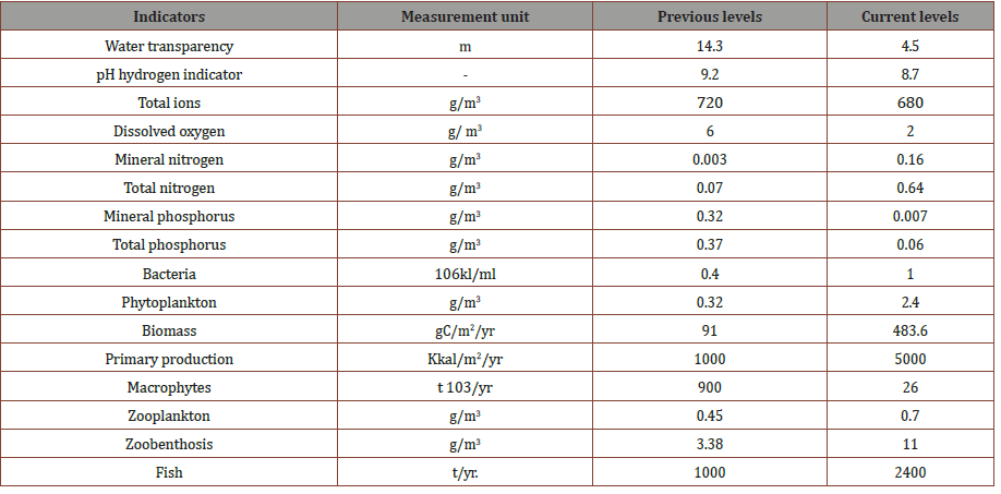
In contrast to numerous other lakes in the world, Lake Sevan had a nutrient regime favorable for biologic activity. The artificial decrease of the lake level, the changes of the hydrological, thermal, saline, and gas regimes could not but affect the biological processes of the lake. Many biological indices have dramatically changed (Table 5).
Most obvious are the changes which have led to more favorable conditions for algae growth and the first signs of the eutrophication. The first signs of the lake’s eutrophication were recorded in 1964, when green and blue algae blossomed in the lake. The changes in the conditions within the lake have led to degradation of the whole ecosystem, and changes in various processes within the area of the lake (including bio-degradation, sedimentation, and diffusion). In the 1960s the number of bacteria per liter was more than twice the concentration found before the drop of the lake level, although the waters still had the conditions of an oligotrophic lake. From the 1980s, however, the number of bacteria doubled again, giving a concentration which now corresponds to the conditions of a mesotrophic lake.
The drainage of the lake also had important effects for the fauna. Drying of parts of the rocky bottom of the lake destroyed the principal trout breeding sites. In addition, around 10 thousand ha of wetland and semi- wetland areas also dried out. These areas were previously used by up to 160 species of migratory birds, and only 50 of these species are now recorded. The populations of mammal and reptile species in the area have also declined significantly, and there is evidence of changes in species composition [26].
A total of 245 species of phytoplankton have been recorded from the water systems of Armenia. Most of these are freshwater species, although some forms are found in brackish water in the Ararat Valley. Over 97 species have been recorded from Lake Sevan alone, among which the Chlorophyta are the most diverse (47 species), and Bacillariophyta are also well represented.
Phytoplankton found in Lake Sevan were previously considered unusual, relative to other large lakes in Western Europe, being adapted to oligotrophic (nutrient poor) conditions.
However, many of these species disappeared during eutrophication of the lake. Indeed, species such as Anabaena (now Dolichospermum) flos-aquae and A. lemmermanii flourished and contributed to the algal bloom which occurred in 1964. By the 1970s species such as Melosira granulata and M. islangica dominated the phytoplankton community of the lake, but further eutrophication in the 1980s reduced their numbers [26].
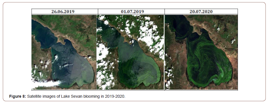
Recent years cyanobacteria have become increasingly dominant in summer in Lake Sevan, reflecting the eutrophication of the lake and formed a massive bloom event (Figure 8). These recent observations mark the transition of this previously oligotrophic high mountain lake into a eutrophic lake with scum‐forming cyanobacterial blooms.
The species of the two taxa Anabaena and Aphanizomenon are the dominant cyanobacterial species in Lake Sevan that often occur in parallel or a sequence. All these observations indicate that Cyanobacteria are not new to this lake, but on the contrary, occur only during specific phases and do not constitute a characteristic and stable feature of Lake Sevan’s phytoplankton community. According to the visible impression of the lake, however, the bloom event in 2018 reached unprecedented levels, and therefore, stirred intense media attention [27-29]. The lake continued to bloom in 2019-2020 too (Figure 8).
Conclusions and Recommendations
Based on the above analysis, the following conclusions and recommendations can be drawn.
Conclusion
In the world limnology, there has been no other case when a lake level would be artificially lowered by 18 meters for 3-4 decades (1930-70 s), and by another 2 meters at the end of 20th century (1990-2000) and the volume of water in the lake decreased from 58 billion m3 to 32 billion m3.
In conclusion, it must be noted that the drop of the lake level, and the economic development in the basin brought about the change in the hydrological regime of the lake. The latter caused the disruption of the hydro chemical and hydrobiological regimes of the lake. The quality of the water deteriorated; water turbidity increased. The inner circulation of the water substances, as well as the circulation of the biological substances altered as well.
In the recent 10 years the water level of the lake has increased by more than two meters, which is the effect of the growth surface flow and decrease of outflow from the lake. As a result, a new issue emerged, namely, the coastal green zone is under water (considerable water lever increase took place so fast and unexpectedly, that there was no time to clear the coastal line from its green cover), thus, endangering the lake with eutrophication anew Well before the artificial change in lake level (In 1893), the total mineralization was 714 mg/l. After 1980 the mineralization sharply decreased, becoming as low as 660.2 mg/l and 647.8 mg/l at present. The decrease of the total general mineralization of the lake water is strongly related to the massive outflow of salty water, removing the salts which had been accumulating in the lake for ages.
There are seasonal variations in mineralization of Lake Sevan waters, a feature rarely seen in other large lakes. Two maxima and minima occur annually, the maxima being observed in the summer and winter low-water period, with minima during the spring and autumn floods.
Form the studied ionic composition, only sulfate ion (SO4) increased about 1.8 times, which affected the taste of water and may promote the growth of bacteria.
Lake Sevan belongs to the type of lakes in which homothermia is observed twice a year, in spring and autumn, after which the water layers mix. This means that the biomaterials accumulated in the ground layer pass into the surface layer. In case, and in favorable conditions, which is the presence of sufficient temperature, the growth of blue-green algae occurs. The higher the content of vital elements, especially “restrictive” phosphorus, the more intense the growth.
A possible cause of the growth of blue-green algae in Lake Sevan is the early water warming and the presence of a sufficient number of vital elements in the lake, especially phosphorus. The amount of oxygen in the bottom layer of the lake is low, which creates favorable conditions for the release of phosphorus from the bottom layer.
Recommendations
Continue to raise the level of Lake Sevan, which will restore the hypolimnion layer and will contribute to the gradual restoration of the lake ecosystem.
Dismantling and transfer of buildings from the coastal zone of the lake to the 1905 m mark and prohibiting the construction of small hydroelectric power plants on the rivers of the lake basin.
A set of works for the restoration and reconstruction of sewer communications and the construction of water treatment facilities in large settlements and cities of the basin.
Expansion and improvement of the environmental monitoring system in the lake and its basin both in terms of geographical coverage and studied pollutants.
Reducing the flow of pollutants (in particular biogenic elements) into the lake and improving water quality.
More research should be done on the negative impacts of mine development (and subsequent crushing / grinding of ore) in the lake basin and appropriate limiting decisions taken.
It is necessary to actively involve local communities, as well as environmental activists in preparing the shores for flooding (cleaning from green spaces and waste), as well as cleaning up already flooded shores.
Afforestation of slopes in the lake basin above the 1905m mark for soil protection and optimization of landscapes.
To contribute to the development of a methodology for calculating the recreational capacity of Lake Sevan in the conditions of changed morphometric, limnological, hydrological and other characteristics, as well as global climate change and carry out studies to evaluate the lake as an important recreational site, determination of permissible norms for recreational loads on the water area and coastal zone, establishing the optimal parameters for their recreational use, in order to ensure a sustainable balance of lake water quality.
Although the RA Ministry of Environment has carried out and is carrying out a number of actions in order to stabilize the ecological condition of the Lake and It is hard to predict the future developments of these processes. However, the issue of lake Sevan is not entirely settled, the ecosystem of the lake is damaged, undergoing the process of eutrophication. The flora and fauna of the water and coast underwent serious and irreversible changes.
To read more about this article...Open access Journal of Hydrology & Meteorology
Please follow the URL to access more information about this article
To know more about our Journals...Iris Publishers
To know about Open Access Publishers


No comments:
Post a Comment